
Revolutionizing Forest Management
For Forest Managers: Explore our suite of advanced, user-friendly solutions specifically designed to streamline operations and promote sustainability in the forest industry.
Tailored Solutions for Comprehensive Forest Management
Our cutting-edge software revolutionize forest management. Our platform offers a suite of modules, each meticulously designed to address key aspects of forest management. From tree inventory to health monitoring, management planning, and ecosystem services, these modules synergize to provide a holistic, efficient, and sustainable approach to managing your forest resources. By harnessing the power of advanced AI and intuitive interfaces, our software empowers you to make data-driven decisions and unlock the full potential of your forests.”
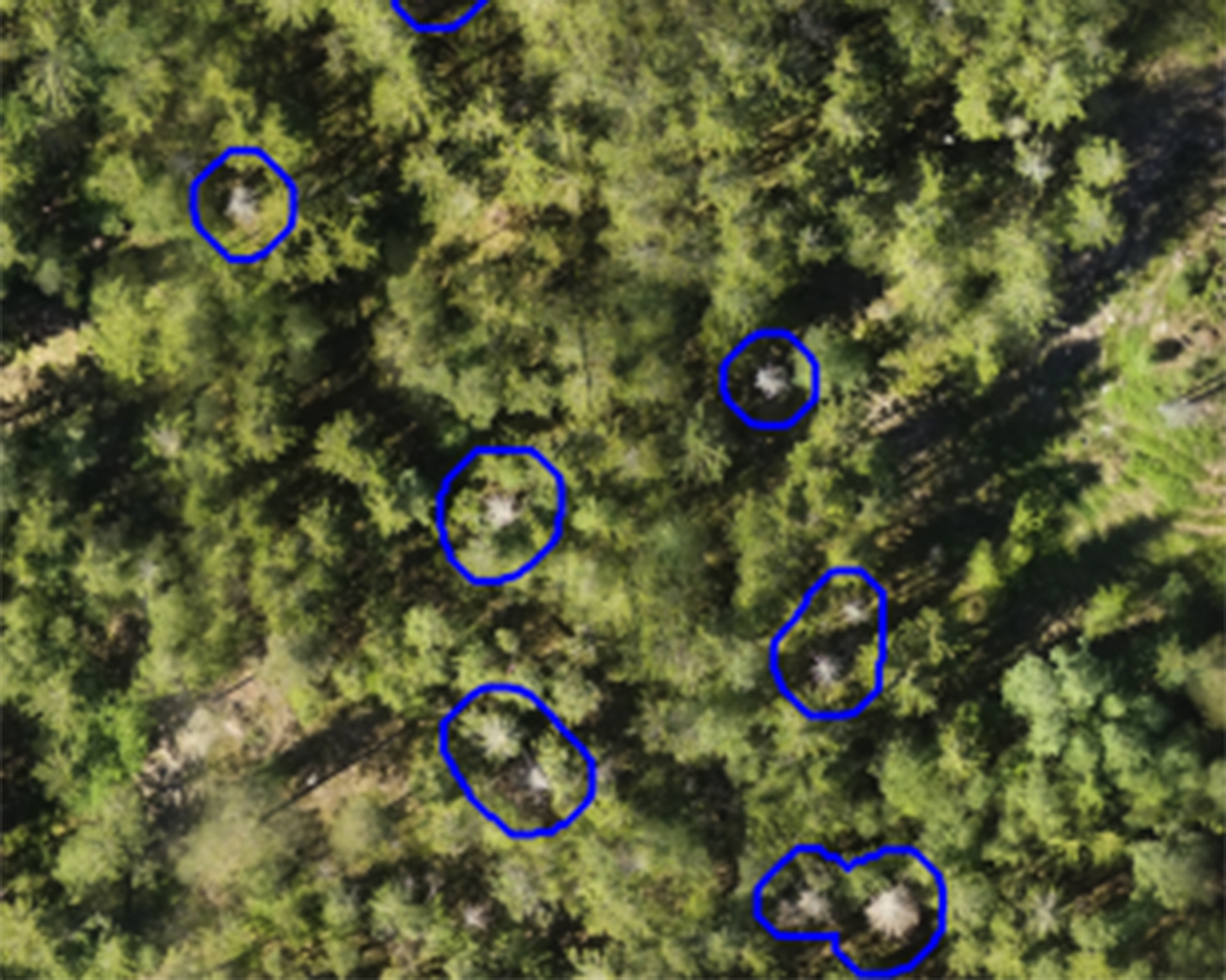
Forest Inventory
Gain a comprehensive forest overview with our Forest Inventory module, effortlessly monitoring tree species and health. Leverage this data for optimized operations and informed decisions. Stay proactive with our Health Monitoring, detecting disease, pest infestations, and health risks before they become detrimental, ensuring the long-term health of your forests.
This module is great to use for:
- Forest Damages analysis
- Tree species inventory

Forest Management
Ensure your forest’s future with our Management Planning module. Use our platform’s predictive capabilities to automatically make effective, data-driven plans for sustainable management from collected data. Identify over 20 tree level parameters like, age, height, stem diameter, cutting class, crown diameter and more.
This module is great to use for:
- Dynamic Forest Management Planning
- Felling Planning
- Tree Level Forest Management
Ecosystem Services
Our Ecosystem Services module helps you understand and quantify the value your forest provides to sustainability. Promote sustainability and profitability through a better understanding of your ecosystem’s contributions.
This module is great to identify:
- CO2 balance for carbon credit verification


A Seamless and Scalable Platform
Our system is built on a robust and scalable infrastructure, ensuring a seamless user experience and optimal performance. Whether you are managing a small forest or a vast woodland, our platform caters to your needs with efficiency and reliability.
You can access our system via our webportal or via API integrations.
Flexible Subscription Plans to Suit Your Needs
Choose from our scalable pricing models, ensuring you only pay for what you need. Our plans are designed with your company in mind, allowing you to adapt and grow at your own pace.
Ondemand
The from time to time solution- Limited number of forest
- Basic functionality
- Forest Inventory
- 30 days data storage
- Knowledge hub and FAQ
- No subscription
- Email and chat support
- Call and meeting support
- Forest Management
- Ecosystem services
- Drone services $
Premium
The professional forest manager- Limited forest area
- Premium functionality
- Forest Inventory
- Forest Management
- Yearly data storage
- Yearly subscription
- Knowledge hub and FAQ
- Email and chat support
- Call and meeting support
- Ecosystem services
- Drone services $
Enterprise
Large forest companies- Unlimited forest areas
- Premium functionality
- Ecosystem services
- Forest Inventory
- Forest Management
- Yearly data storage
- Yearly subscription
- Knowledge hub and FAQ
- Email and chat support
- Call and meeting support
- Extra services per request
Offer based services
Through Arboair you also have the possibility to purchase services from our partners and suppliers. We have a wide range of partners that we can take in offers from.
Satellite images
Available resolution from our partners is:
1. High. Res = 30cmx30cm and 50cmx50cm. Bands. 4 bands and 8 band bundles.
2. Medium. Res = 3mx3m per pixel. Bands = 4 bands bundle
3. Low. Res = 10mx10m per pixel. Bands = 8 bands bundle.
Our satellite partner:
Drone missions
Our partners do all kinds of drone missions and we have drone pilots with expertise in forest missions.
For missions our partner pilots can take up to 500ha/day, following our drone guide.
Our drone partners:
Help in the forest?
Some of our partners are experts in forest management and forest planning. If you need help with your decision-making based on the results our partners will help you!
If you need help with getting a digital forest management plan we work with partners that can help!
Inventory as a Service
We at Arboair can help you with your forest inventory on a project basis!
We can help you map:
- tree volumes
- tree species
- tree count
- tree heights
- forest damages
- ondemand features
Contact us for more info of how we can help you!
Forests analysed
Analyzed hectares
Saved trees
Saved value M €
CO2 Saved (ton)
Sounds interesting?
Help us evolve!
Interested in investing? Click here.
Or maybe you could help us develop this tool of the future? Browse or contact us for open positions!